 Since its formation over 4.5 billion years ago, Mars has undergone many geologic and environmental changes, including water accumulation. In March of 2006, NASA’s MRO (Mars Reconnaissance Orbiter) manoeuvred into a stable orbit around Mars to examine how that water was distributed and to observe seasonal variations over many years. MRO’s daily observations of shifting sand dunes, widespread dust storms, and seasonal ice revealed the dynamic environment and history of Mars.
MRO is examining whether underground ice, discovered by previous Mars missions, is the top layer of a deep ice deposit or a shallow layer in equilibrium with the atmosphere and its seasonal cycle of water vapour. It looks for evidence of shorelines of ancient seas and lakes, as well as deposits placed in layers over time by flowing water.
HiRISE Camera
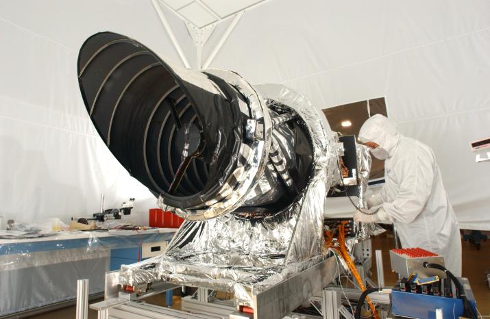
Credit: NASA/JPL/Ball Aerospace
The main imaging instrument on the MRO is the High-Resolution Imaging Science Experiment (HiRISE): a powerful camera that covers vast areas of Martian terrain, magnifies surface details, and analyzes mineral composition. To ensure that the lighting is as consistent as possible, MRO’s sun-synchronous orbit enables image acquisition at the same time every Martian day or “sol”. The high-resolution images collected by HiRISE reveal unprecedented views of layered materials, gullies, channels, and other science targets, in addition to characterizing possible future landing sites.
HiRISE is a “pushbroom” camera that builds an image by collecting data along a line of detectors as MRO travels across its orbit. The overall image has a swath width of 3.7 miles (6 kilometres) and a programmable image length of up to 37 miles (60 kilometres). Unlike classic line-scan cameras with a single row of detectors, HiRISE uses Time-Delay Integration (TDI) and integrates signal from up to 128 rows for a better signal-to-noise ratio. The 14 Teledyne e2v CCD89 detectors in HiRISE’s focal plane are offset to overlap the ends of the detectors and avoid coverage gaps. Each CCD can be commanded independently with different pixel scales and numbers of TDI lines, depending on various constraints.
From an altitude of 250 miles (400 kilometres), HiRISE can resolve objects down to three feet (one meter). That is a major improvement over previous Mars orbiters capable of identifying objects no smaller than 35 feet across. Such telescopic power allows scientists to study the surface of Mars in much greater detail and to identify obstacles such as large rocks. That data is useful for advancing our understanding of the geography of Mars and is used to navigate the rovers currently on the surface, such as Curiosity, and Perseverance.
HiRISE also makes observations at near-infrared wavelengths to obtain information on the mineral groups present. Each CCD is covered by a filter in one of three wavelength bands: 400 to 600 nanometers (blue-green), 550 to 850 nanometers (red), or 800 to 1000 nanometers (near-infrared). Scientists can combine this mineral data with navigational data to help select landing sites for upcoming missions like the Rosalind Franklin rover. The goal is to optimize mineral and water availability with navigational feasibility to maximize the chances of finding life on Mars.
Confirming Sources of Water
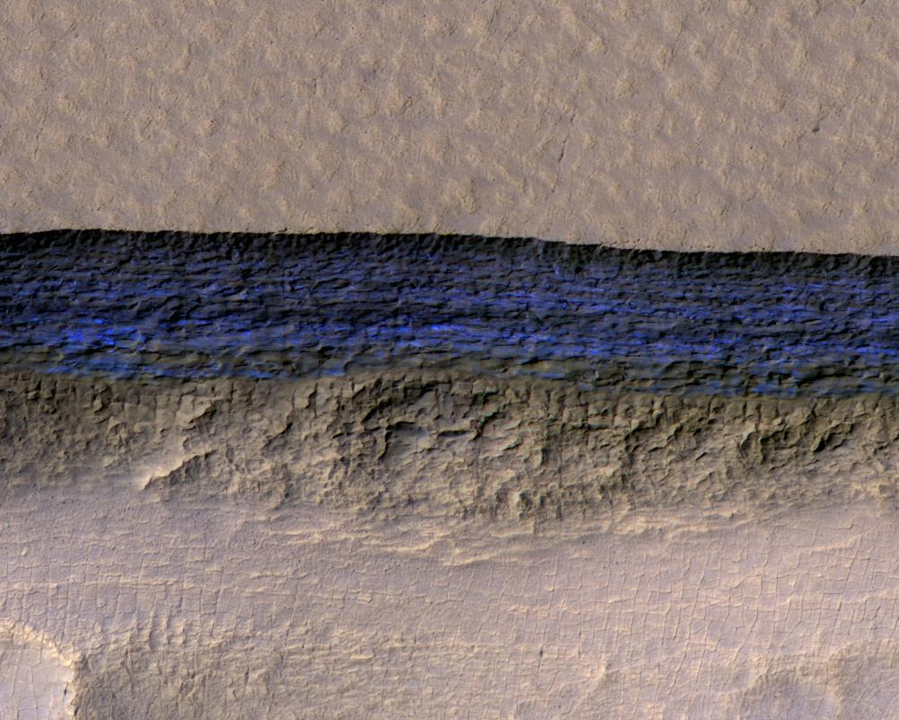 A cross-section of a thick sheet of underground ice is exposed at the steep slope (or scarp) that appears bright blue in this enhanced-color view from the High Resolution Imaging Science Experiment (HiRISE) camera on NASA's Mars Reconnaissance Orbiter. Credit: NASA/JPL-Caltech/UA/USGS
Confirming water locations on Mars could be invaluable for planning future human expeditions since astronauts will need water for survival and oxygen for rocket propellant to return to Earth. MRO has identified eight freely accessible ice veins that could be viable water sources. Additionally, the exposed cross-section of ice, likely deposited as snow, contains details about long-term patterns in Mars' climate.
The orbiter's observations of mineral composition, such as hydrated salts, and surface shape changes show evidence that liquid water on the surface of Mars was present one billion years longer than previously estimated.
Scientists theorized that Mars had two major epochs – an early wet climate, followed by the current dry, cold conditions. The diverse landscape examined by MRO shows evidence that the transition happened at different rates in different areas. It is now understood that Mars had a middle phase during which a series of intermittent ice ages cycled over several hundred thousand years. Water ice then transformed from a solid directly to gas from the periodically warmer summertime polar caps and was transported to the rest of the planet, forming lower-latitude ice deposits. Today's mid-latitude ice deposits are thought to be remnants of that most recent ice age.
This image of the western Utopia Planitia in the Northern mid-latitudes of Mars show evidence of water ice. The scalloped depressions probably formed as ice-rich subsurface material was removed by natural sublimation. Furthermore, a network of polygonal fractures indicate the presence of ground ice.
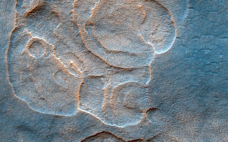
Credit: NASA/JPL-Caltech/Univ. of Arizona
Mars Relay Network

The Mars 2020 descent stage holding NASA’s Perseverance rover can be seen falling through the Martian atmosphere by the Mars Reconnaissance Orbiter’s HiRISE camera, its parachute trailing behind. Credit: NASA/JPL/UArizona
While MRO completed its original mission in 2010, it continues to gather data and support other Mars missions.
All the images collected by MRO, and the many other missions currently exploring Mars, would be useless if it couldn’t be received on Earth. While rovers on the surface can transmit and receive commands and telemetry data directly, it would take far too long to directly transmit the enormous volume of science data they collect. As a result, most of that science data is sent up to spacecraft orbiting overhead, through the Mars Relay Network. The network includes other missions such as ESA’s Trace Gas Orbiter, and captures data from rovers like NASA's Perseverance and Curiosity.
A Brief History of HiRise
Watch a Brief History of HiRise by Alfred McEwen, Regents Professor, University of Arizona, Principal Investigator of HiRise.

