The SPOT-5 satellite conducted tele-epidemiology, created high-resolution 3D maps, assisted in natural disaster response, and could identify most plant species. While the initial proposal for SPOT-5 called for a pair of spacecraft, the singular SPOT-5–in coordination with SPOT predecessors–still delivered the high-resolution images required by the scientific community. 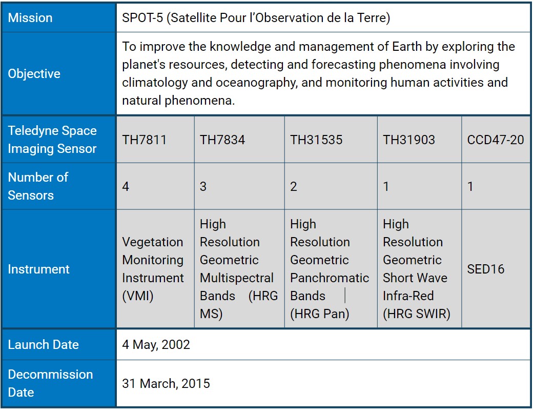 The SPOT-5 mission was designed to image land and vegetation for monitoring, mapping, and planning purposes. A particular consideration was that CNES wanted to improve SPOT's imaging capabilities while maintaining compatibility with its predecessors still in orbit. In other words, SPOT-5 had to have the same geometric imaging characteristics: a swath of 60 km per instrument and the same oblique viewing angle.
The initial proposal for the next iteration of the SPOT series called for two identical spacecraft and two new optical imagers for these spacecraft to take images with a 5-metre ground resolution. However, the programme was downsized to one orbiting spacecraft. As a result, CNES developed an innovative image acquisition and processing scheme–Supermode–to obtain a 2.5-metre spatial resolution from two 5-metre images.
SPOT-5 image of Copenhagen (Denmark) acquired 21 April 2011. Credit: Airbus Defence and Space
SPOT-5 also carried a Vegetation-2 instrument identical to the Vegetation Monitoring Instrument on SPOT 4 and two new HRG instruments derived from SPOT 4's HRVIR instruments. The HRG sensors collected data in five spectral bands, with one panchromatic (PAN) band, three multispectral (MS) bands and one shortwave infrared (SWIR) band. Vegetation-2 and HRS worked in conjunction to provide multi-purpose imagery of land and ocean, with more specific data collection of vegetation, land topography and snow and ice topography.
Achievements and Legacy
Building upon the experience of designing its four predecessors, SPOT-5 offered enhanced capabilities, improving resolution to 5 and 2.5 metres with the same wide imaging swath covering 60 x 60 km or 60 km x 120 km. In twin-instrument mode, the satellite provided an ideal balance between high resolution and wide-area coverage. The high-resolution mode and SWIR capability enabled SPOT-5 to recognise most plant species and inventory them. It can also detect illegal crops often planted in remote regions.
SPOT-5's other key feature was the unprecedented acquisition capability of the onboard HRS stereo viewing instrument, which acquires stereo images over vast areas in a single pass. Stereopair imagery is vital for applications that require 3D terrain modelling and computer environments, such as flight simulator databases, pipeline corridors, and mobile phone network planning.
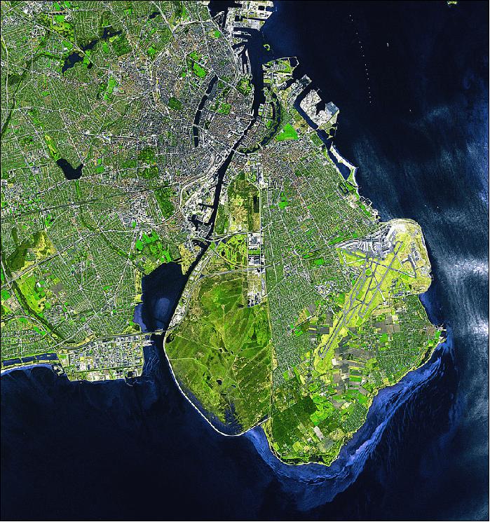
Cairo and the Pyramids viewed by SPOT 5. Credit: CNES/distribution Spot Image, 2003
Over its 13-year lifespan, SPOT-5 took over 11,833,000 images of the Earth, 24% without any cloud cover and 36% with less than 10% cloud cover. That represents over 42,600,000,000 km2 of the Earth covered. More than 1500 customers from 120 countries have used SPOT 5’s images.
In 2010, hours after the devastating January 12 earthquake struck Haiti, SPOT imagery was used to assist in disaster response efforts. SPOT-5 captured its first image of Port-au-Prince on Jan. 14 and several more over the surrounding parts of Haiti in subsequent days. As per international agreements around sharing remote sensing data during natural disasters, the U.S. government used images of Haiti taken by SPOT-5 for logistics planning before deploying response personnel and managing resources in the field.

Animation showing the spread of forest fires in southern France, summer 2003, viewed by the HRG instrument on SPOT 5 (2.5-m resolution). Credit: CNES
After the destructive Japanese earthquake of March 11, 2011, the International Charter on Space and Major Disasters tasked SPOT-5 with covering the coast that was hit by the full force of the subsequent tsunami.
SPOT-5 contributed to the MARS-PAC programme (Monitoring Agriculture by Remote Sensing-Politique Agricole Commune) carried out by the European Union, providing several hundred images per year, covering 120 to 150 sites selected by the 15 member countries. This agricultural monitoring helped calculate a rapid estimation of surface areas and potential yields in Europe.
Instruments on SPOT-5 collected entomological and surface reflectance data to study and monitor diseases; using space technology to conduct tele-epidemiology. SPOT-5 identified areas of standing water and vegetation cover in urban and rural locations to study Dengue in Argentina, Malaria in Algeria, Burkina Faso, Paraguay, and Senegal, and Rift Valley Fever in Senegal. In collaboration with ENVISAT, another satellite with Teledyne Space Imaging sensors, SPOT-5 helped study Bilharzia around the Poyang Lake in China and Vibrion-related diseases in the Mediterranean Sea.
Upon mission conclusion in March 2015, the satellite was repurposed for the second part of the TAKE 5experimental commercial mission. As had been done with SPOT-4, SPOT-5 lowered its orbit by 2.5 km to increase the revisit rate and acquire images of about 150 predefined sites every five days for five months. This orbit replicated ESA's SENTINEL-2 satellites, which would launch in 2015 and 2017 and be equipped with Teledyne Space Imaging sensors.
Banner Image Credit: Soccer City Stadium, South Africa, KARI 2010 distribution SPOT Image.

